Zarqali, Abu Ishaq Ibrahim al- / Bianchini, Giovanni (ed.). 
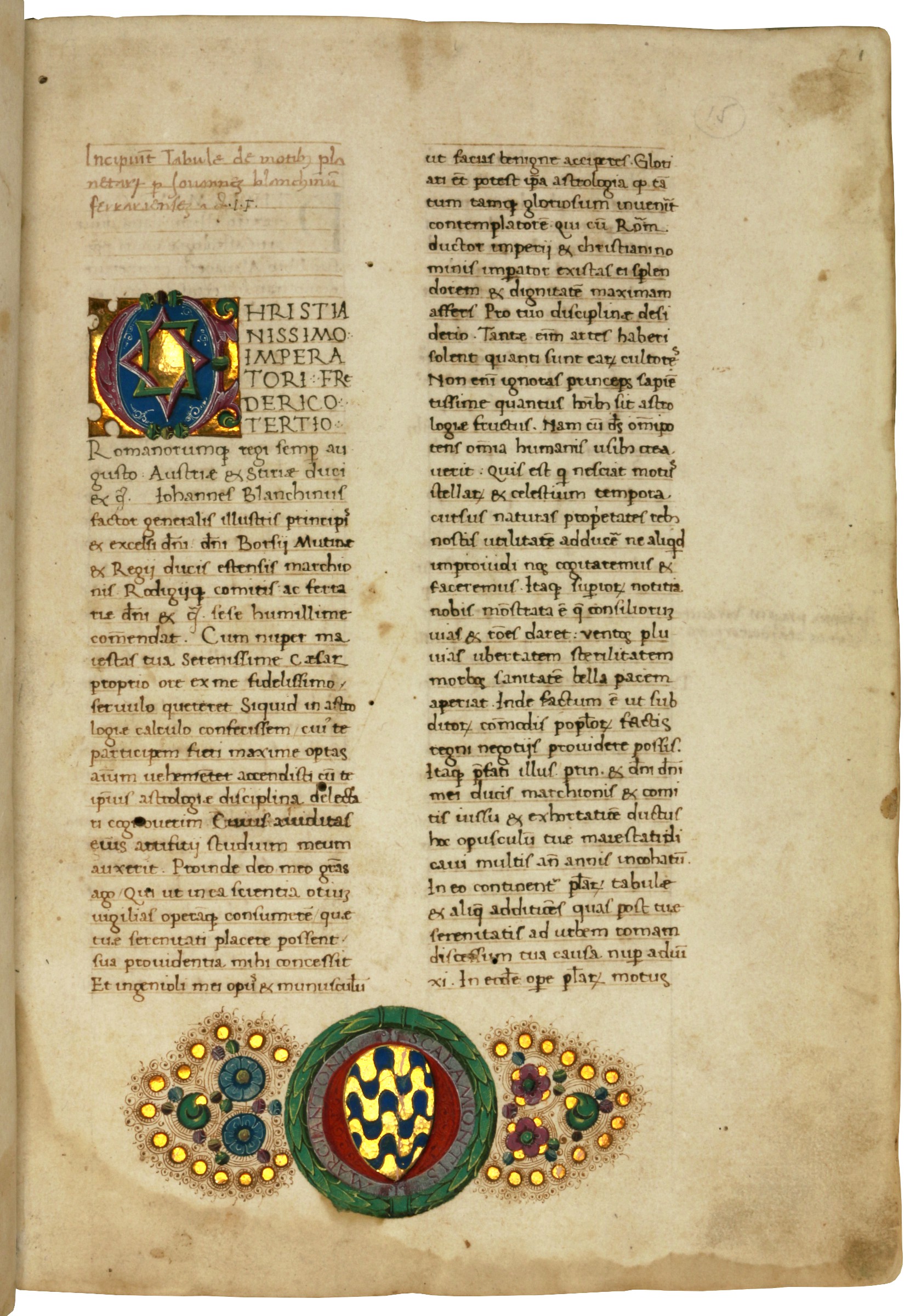
Tabulae de motibus planetarum.Ferrara, ca. 1475.

The so-called "Toledan Tables" are astronomical tables used to predict the movements of the Sun, Moon and planets relative to the fixed stars. They were completed around the year 1080 at Toledo by a group of Arab astronomers, led by the mathematician and astronomer Al-Zarqali (known to the Western World as Arzachel), and were first updated in the 1270s, afterwards to be referred to as the "Alfonsine Tables of Toledo". Named after their sponsor King Alfonso X, it "is not surprising that" these tables "originated in Castile because Christians in the 13th century had easiest access there to the Arabic scientific material that had reached its highest scientific level in Muslim Spain or al-Andalus in the 11th century" (Goldstein 2003, 1). The Toledan Tables were undoubtedly the most widely used astronomical tables in medieval Latin astronomy, but it was Giovanni Bianchini whose rigorous mathematical approach made them available in a form that could finally be used by early modern astronomy.

Bianchini was in fact "the first mathematician in the West to use purely decimal tables" and decimal fractions (Feingold, 20) by applying with precision the tenth-century discoveries of the Arab mathematician Abu'l-Hasan al-Uqilidisi, which had been further developed in the Islamic world through the writings of Al-Kashi and others (cf. Rashed, 88 and 128ff.). Despite the fact that they had been widely discussed and applied in the Arab world throughout a period of five centuries, decimal fractions had never been used in the West until Bianchini availed himself of them for his trigonometric tables in the "Tabulae de motis planetarum". It is this very work in which he set out to achieve a correction of the Alfonsine Tables by those of Ptolemy. "Thorndike observes that historically, many have erred by neglecting, because of their difficulty, the Alfonsine Tables for longitude and the Ptolemaic for finding the latitude of the planets. Accordingly, in his Tables Bianchini has combined the conclusions, roots and movements of the planets by longitude of the Alfonsine Tables with the Ptolemaic for latitude" (Tomash, 141).

The importance of the present work, today regarded as representative of the scientific revolutions in practical mathematics and astronomy on the eve of the Age of Discovery, is underlined by the fact that it was not merely dedicated but also physically presented by the author to the Holy Roman Emperor Frederick II in person on the occasion of Frederick's visit to Ferrara. In return for his "Tabulae", a "book of practical astronomy, containing numbers representing predicted times and positions to be used by the emperor's […] astrologers in managing the future" (Westman, 10ff.), Bianchini was granted a title of nobility by the sovereign.

For Regiomontanus, who studied under Bianchini together with Peurbach, the author of the "Tabulae" counted as the greatest astronomer of all time, and to this day Bianchini's work is considered "the largest set of astronomical tables produced in the West before modern times" (Chabbas 2009, VIII). Even Copernicus, a century later, still depended on the "Tabulae" for planetary latitude (cf. Goldstein 2003, 573), which led to Al-Zarquali's Tables - transmitted in Bianchini's adaption - ultimately playing a part in one of the greatest revolutions in the history of science: the 16th century shift from geocentrism to the heliocentric model.

In the year 1495, some 20 years after our manuscript was written, Bianchini's Tables were printed for the first time, followed by editions in 1526 and 1563. Apart from these printed versions, quite a few manuscript copies of his work are known in western libraries - often comprising only the 231 full-page Tables but omitting the 68-page introductory matter explaining how they were calculated and meant to be used, which is present in our manuscript. Among the known manuscripts in public collections is one copied by Regiomontanus, and another written entirely in Copernicus's hand (underlining the significance of the Tables for the scientific revolution indicated above), but surprisingly not one has survived outside Europe. Indeed, the only U.S. copy recorded by Faye (cf. below) was the present manuscript, then in the collection of Robert Honeyman. There was not then, nor is there now, any copy of this manuscript in an American institution. Together with one other specimen in the Erwin Tomash Library, our manuscript is the only preserved manuscript witness for this "crucial text in the history of science" (Goldstein 2003, publisher's blurb) in private hands. Apart from these two examples, no manuscript version of Bianchini's "Tabulae" has ever shown up in the trade or at auctions (according to a census based on all accessible sources).

Condition: watermarks identifiable as Briquet 3387 (ecclesiastical hat, attested in Florence 1465) and 2667 (Basilisk, attested to Ferrara and Mantua 1447/1450). Early manuscript astronomical table for the year 1490 mounted onto lower pastedown. Minor waterstaining in initial leaves and a little worming at back, but generally clean and in a fine state of preservation. Italian binding sympathetically rebacked, edges of covers worn to wooden boards. A precious manuscript, complete and well preserved in its original, first binding.

Provenance: 1) Written ca 1475 by Francesco da Quattro Castella (his entry on fol. 150v) for 2) Marco Antonio Scalamonte from the patrician family of Ancona, who became a senator in Rome in 1502 (his illuminated coat of arms on fol. 1r). 3) Later in an as yet unidentified 19th century collection of apparently considerable size (circular paper label on spine "S. III. NN. Blanchinus. MS.XV. fol. 43150"). 4) Robert Honeyman, Jr. (1928-1987), probably the most prominent U.S. collector of scientific books and manuscripts in the 20th century, who "had a particular interest in astronomy" (S. Horobin, 238), his shelf mark "Astronomy MS 1" on front pastedown. 5) Honeyman Collection of Scientific Books and Manuscripts, Part III, Sotheby's, London, Wed May 2, 1979, lot 1110, sold to 6) Alan Thomas (1911-1992), his catalogue 43.2 (1981), sold to 7) Hans Peter Kraus (1907-1988), sold to 8) UK private collection.

Shah 'Alam II, 17th Mughal emperor (1728-1806). Handwritten Mughal firman with seal.Delhi, 1757 CE = 1171 H.

From the 17th Mughal emperor to the founder of the Scindia dynasty: an elegantly written firman issuing a decree from Shah 'Alam II requesting aid from his ally, Mahadaji Shinde (1730-94):

"I, Shah 'Alam, the Mughal emperor, offer my venerable greetings to Mahadaji Scindia, my sincere, loyal, and dear friend. In these snowy days when the shadow of Ahmad Shah Durrani is falling down upon our empire, I want you, honourable Mahadaji, to stand beside me, in the defending our beloved land".

As ruler of the ailing Mughal empire, Shah 'Alam was in a difficult position; by 1757 he had been facing incursions by Ahmad Shah Durrani, father of modern Afghanistan, for a decade. He increasingly turned to the Marathis in the south for aid, and specifically to Mahadaji Scindia. The year this firman was written, Mahadaji's star was still rising: within a few decades, it would be Mahadaji who brought the Maratha Confederacy to dominate the subcontinent, firmly established the Scindia dynasty, and rose to personally rule as both Raja of Gwalior and Naib Vakil of the Mughal Empire. He re-established Shah 'Alam himself on the Mughal throne, having personally retrieved him from a temporary exile, and defeated the British at the Battle of Wadgaon.

Shah 'Alam's compliments to Mahadaji in this 1757 firman become almost prophetic: "Know that your bravery and commitment to the Mughal ideals will forever be recorded in history. May our united forces thwart the ambitions of Ahmad Shah Durrani and protect the sovereignty of our empire. Our pain is in your hands; I entrust [to you] the honour and safety of our people. May the flags be raised. And may our alliance stand as an unconquerable force against any threat, which seeks to undermine the glory of Mughal empire".

The official whose seal is placed on Shah 'Alam's decree is Shja'al-Dawla Bahadur, governor of Oudh and Allahabad who was later appointed the prime minister by Shah 'Alam.

Full translation available upon request.

Aurangzeb (Muhi al-Din Muhammad), sixth Mughal emperor (1618-1707 CE). Handwritten Mughal firman with seal.Mughal India, 1669 CE = 1079 H.

From the ruler of nearly all of the Subcontinent to his sister, the most powerful woman in the empire: the seal of Mughal emperor Aurangzeb features prominently atop this elegantly written firman, which decrees the emperor's condolences and honours to the family of his sister, Jahanara Begum (1614-81 CE).

Like her brothers, Jahanara grew up amidst Mughal politics. Upon the death of her mother the empress, her father named 17-year-old Jahanara as Padshah Begum, or First Lady of the empire: head of the haram and keeper of the emperor's seal (an example of which is displayed so prominently on this firman). This honour would normally have fallen to one of emperor's three surviving wives, not a daughter, but Jahanara held it until her father's illness sparked a war of succession between her brothers. Jahanara sided not with Aurangzeb but with their elder brother Dara Sikoh (1615-59 CE), a fellow Sufi who held Jahanara's reservations about Aurangzeb's hardline orthodoxy. When Dara was nevertheless defeated and assassinated, Aurangzeb took the throne and awarded a younger sister and rival of Jahanara's the title of First Lady - for a time.

Jahanara remained with their imprisoned father until his death in 1666, three years before this decree, at which point she emerged and reconciled with Aurangzeb. Her title of First Lady was returned to her, along with new titles and lands.

Issued just three years after Jahanara's re-emergence into court life, this decree is a record of this important, and sometimes calamitous, sibling relationship between the most powerful man and woman in an Mughal empire. The name of Jahanara's deceased relative is not stated, but he is named as a descendant of Mullah Abdul Qadir Badayuni, and is described in suitably glowing terms: "the precious, respected and honorable Leader of Leaders". It is worth noting, additionally, that Jahanara's role as Padshah Begum required that she wield the emperor's seal; it is not impossible that she did so here.

Full translation available upon request.

Gaubil, Antoine, Jesuit missionary, astronomer, and historian at the Imperial Court in Beijing (1689-1759). "Catalogue pour la lune et les 5 planètes". Autograph manuscript.Beijing, 1735.

A chronological survey of the movements and positions of the moon and the five planets between 147 BC and AD 1735, compiled from Chinese works. Beyond the tables of observations, Gaubil offers highly interesting notes and remarks on the observations themselves, Chinese astronomical terminology, as well as the history, practice, and relevance of lunar observation in China, especially with respect to the lunar calendar, dynastic chronology, and astrology.

Two particularly interesting notes are found towards the end of the manuscripts on pp. 29 and 31, respectively. In the first note, Gaubil mentions his source and prides himself with surpassing comparable Chinese compilations: "It is from the astronomy of the dynasties that I have drawn the calculations or observations shown in these 29 pages. Several Chinese have made these kinds of compendiums, but they are unselective, truncated and full of errors" (transl.). The following note directs the reader's attention to the high esteem that Jesuit astronomers enjoyed at the Imperial Court in Beijing: "The mandarins appointed by the Emperor to work with the Jesuits to reform the Calendar gave an account of their commissions. In particular, they pointed out the shortcomings of the Ephemerides for the year 1634. It is here that they state that the Chinese do not speak of the latitude or declination of the planets, and that even the longitudes of the planets are very often incorrect" (transl.).

Gaubil sent the manuscript to his editor Étienne Souciet SJ (1671-1744), librarian at the Collège Louis-le-Grand in Paris, who added his note of receipt on 17 August 1752 in ink to the first page. Gaubil himself noted, "sent catalogue of constellations", apparently indicating another manuscript. The later pencil foliation ("153-168"), possibly added by Souciet, appears to indicate a publication project, but the manuscript was not published in Souciet's Observations and is not listed by Pfister.

Antoine Gaubil, who arrived in Beijing in 1722 and would remain there for the rest of his life, was the most important astronomer among the French Jesuits in China, and one of the greatest disseminators of Chinese science and wisdom in Europe in the 18th century. His work on astronomy and as a historian and translator of important Chinese texts such as the "I Ching" earned him the praise of Alexander von Humboldt as the wisest of the Jesuit missionaries. Needham even considers him "the interpreter general and father superior of Chinese astronomy".

Hans Holbein the Younger / Chamberlaine, John (ed.). Imitations of Original Drawings by Hans Holbein, in the Collection of His …London, 1792-1800.

A fine copy of the first edition. This impressive example of 18th century British colour printing in an elaborate binding, boasting over eighty very fine plates, has been hailed as the best of its kind: "This magnificent work is surely the finest example of English color printing" (Ray); "In every way a splendid book" (Abbey). The original Holbein drawings upon which these prints are based were nearly lost, and were hardly seen for centuries until their rediscovery by none other than Queen Caroline of England. Upon being liberated from a bureau of the queen's personal closet at Kensington Palace, colour printed 'imitations' of the drawings were subsequently published under the auspices of John Chamberlaine (1745-1812), Keeper of the drawings of George III. Hardie writes of the copies that "there are few, if any, results more successfully and adequately achieved than these stippled illustrations". Biographical notices were provided by Edmund Lodge (1756-1839), and the whole work was issued over the years 1792 to 1800, with plates known in several states. The present copy includes plates on pink paper, on pink paper mounted on white sheets, and a few on white paper.

Holbein's portraits of the court of Henry VIII are not only beloved for their striking and vivid artistry, but for the way they define the image of the entire Tudor period. The finely produced prints showcase Holbein's abilities as a portraitist of some of the most famous - and infamous - faces in British history.

[Waqidi, Abu Abd Allah al-]. Futuh Ifriqiya [The Conquest of Ifriqiya].Sub-Saharan Africa or Sudan, 16 January 1898 CE = 22 Sha'ban 1315 H.

A Sub-Saharan or Sudanese manuscript on the conquest of Africa through Uqba ibn Amir (d. 677/8 CE) under the reign of the Caliph Uthman (ca. 576-656 CE), closely based on the work by the Golden Age historian al-Waqidi (ca. 747-823 CE). While some passages are identical to al-Waqidi's history, other sections have been omitted and new information has been added, suggesting a work with several sources, among which Al-Waqidi is the predominant one.

The focus of this chronicle is important to the history both of Africa as well as of Islam: aside from their secular roles, Caliph Uthman and the conqueror Uqba ibn Amir were both companions of the Prophet Muhammad. Uthman ruled over the Rashidun Caliphate at the pinnacle of its power and expanse, including Mediterranean Africa and Nubia (today largely Sudan). It is particularly interesting that this is, as identified by its script and style, a sub-Saharan or Sudanese manuscript, an African manuscript on the history of Africa - though its main source, the historian Al-Waqidi, was a native of Medina. While largely based on and paraphrasing al-Waqidi's work, this manuscript is the only extant variant of "Futuh Ifriqiya" of its kind we have been able to identify, and may be a unique text.

[Franco-Prussian War - Ambulances de la Presse]. Printed passport with handwritten entries.Paris, 20 Dec 1870.

Rare document issued during the Siege of Paris by the Ambulances de la Presse for a Parisian servant named Dufresne, accrediting him as a first responder and requesting free passage for him: "Laissez-Passer - Monsieur Dufresne, domestique, demeurant 7 Rue Greffhule [!] attaché aux Ambulances de la Presse, annexes du Ministère de la Guerre, pour relever les blessés sur le camp de bataille".

The Ambulances de la Presse were founded on an initiative of the French press in September 1870 after the collapse of the Second French Empire and would be active beyond the end of the war, until some weeks after the fall of the Paris Commune. The document was issued in the name of the general secretary of the Ambulances de la Presse, the famous journalist and editor at Le Figaro, Albert Dardenne de la Grangerie.

Stamped "Payé". Somewhat soiled and minor foxing, several minor tears and traces of folds.

[Switzerland - Vaud]. Printed passport with handwritten entries.Nyon, 21 Jan 1794.

Interesting document from the final years of Bernese rule in Vaud and Nyon, as highlighted by Bern's woodcut coat of arms at the head of the form. The passport was issued by M. Aneth, secretary to the bailiff of Nyon, in the name of Jean Gaudin, a young man from nearby Begnins who was travelling to Geneva and back. It includes a description of Gaudin's appearance, also mentioning the amount of money he was carrying. Gaudin's entering and departing from the canton of Geneva in Versoix were noted by two different magistrates, one entry dated 24 Ventôse II (14 February 1794).

While the Revolution had reached Geneva as early as 1792, with rather tumultous consequences, the Canton of Vaud would drive out the Bernese governor in 1798 (with the support of French troops), ending 360 years of foreign rule. The newly-declared Lemanic Republic would soon be incorporated as a canton to the Helvetic Republic (1798-1803).

Minor browning and mimal tears.

[Nicolotti, T.]. Bombardamento della citta di Tolone fatto da gl' Imperiali ed Aleati l'Anno …No place, ca. 1707.

Rare, decorative manuscript map of the 1707 Siege of Toulon on the French Riviera during the War of the Spanish Succession. Carried out meticulously and in great detail, it features a lovely cartouche in the lower right corner. The map indicates the town and port of Toulon, the forts of Santa Catarina and Sainte-Marguerite, both briefly held by the Allies, the towns of La Valette-du-Var, Ardenes, and the hospital on Saint-Mandrier-sur-Mer, along with powder magazines and encampments against the rolling hinterlands.

A nearly identical map, signed by the Italian draughtsman T. Nicolotti (fl. 1701-07) and drawn as a trompe l'oeil inset within a larger map of the coast of France and Italy that showing the marches and camps of the Allied and French armies in 1707, is owned by the Royal Collection Trust (RCIN 725097). It differs from the present map merely in colouring and the arrangement of the legend text.

The siege of Toulon took place between 29 July and 21 August 1707, when a combined Savoyard-Imperial army, supported by a British naval force, attacked the French base at Toulon. The town successfully resisted the siege, while thousands of Allied troops were incapacitated by disease.

Two sections somewhat browned. Lower right corner of the backing board chipped, with slight loss to legend text. The pierced cardboard backing suggests that the map was once wall-mounted.

[Saudi Arabia]. [Mineral Occurence Database].Saudi Arabia, no date.

Rare user's guide for the Mineral Occurence Documentation System (MODS), a database constituting the main mineral information base of the Kingdom of Saudi Arabia. The personal copy of Dr. Soliman Mahmoud Soliman, professor of Geology in Qatar (and previously of Ain Shams University in Cairo), who published prolifically on topics related to oil prospecting; his ownership to front cover.

As stated in the introduction, the database was prepared by the French Bureau of Geological and Mining Research, a scientific institution also providing expertise and resources for mining operations. In French regions and abroad, BRGM, with its growing reputation as the subsurface specialist, was increasingly called upon. Their database aims to contain information related to every mineral and non-metallic reservoir located in the Kingdom of Saudi Arabia. Operating to this day, MODS provides detailed data on mineral resources and prospecting projects, including geochemical and geophysical surveys, geologic mapping, and drilling.

Soliman, M. Soliman / Fetouh, Magdi A. El. Carboniferous of Egypt: Isopach and Lithofacies maps.No place, 1970.

Rare scientific paper on the carboniferous rocks of northern, Egypt issued by Dr. Soliman Mahmoud Soliman, professor of Geology in Qatar (and previously of Ain Shams University in Cairo), who published prolifically on topics related to oil prospecting. After a thorough geological analysis revealing the absence of source rocks, the present paper concludes that the petroleum found in the carboniferous strata of oil fields in the Gulf of Suez province probably migrated from younger strata. Illustrated with detailed geological maps of northern Egypt.

Reprinted for private circulation from the American Association of Petroleum Geologists Bulletin, vol. 54, no. 10, October 1970.

In excellent condition.

UNESCO. Bulletin of the UNESCO Regional Office for Science and Technology in the …Cairo, July-September 1976.

Rare issue of the quarterly newsletter of the UNESCO Regional Office for Science and Technology in the Arab States (ROSTAS) based in Cairo. Printed entirely in Arabic, the bulletin includes a statement on the "Conference of Ministers of Arab States responsible for the Application of Science and Technology to Development", held in Rabat from 16 to 25 August 1976, as well as a report on the history and work of ROSTAS. With a quotation by the Muslim scholar Ibn Khaldun on rear wrappers, including an English translation by Franz Rosenthal.

Manuscript Arabic ownership to front cover. Small tears to spine. Otherwise in fine condition.

Egyptian General Petroleum Corporation. Advertising postcard.Egypt, 1960s.

Advertising postcard promoting Egyptian General Petroleum lubricants, reminding drivers to take their car to the nearest service station. Although not primarily intended for postage, it is essentially a picture postcard complete with address field and stamp panel, handed out at filling stations and other points of sale as part of a General Petroleum promotion campaign.

In excellent condition.

[Qur'an]. Esberg, Johan [praes.] / Fahlen, Erik [resp.]. [Adghath ahlam al-Qur'an] sive historiola Alcorani et fraudum Muhammedis.Uppsala, 1699.

A very early Swedish treatise on the Qur'an (and, careful not to appear too interested, on "Muhammad's deception"). The woodcut tailpiece is a Qur'anic verse (sura 56:79): "Let only the pure touch it" (known as the "nemo tangat nisi mundatus" formula in Latin), derived from Schickard's "Jus regium Hebraeorum" (Leipzig, 1674). "Koranic quotations in the work are in Hebrew characters, owing to the lack of Arabic types, as the author explains in an additionally printed preliminary leaf. On p. 48 the author prints a quotation from the Testamentum published by Nicelius in 1655" (Smitskamp).

The author, among his many pursuits, was a professor of Greek at Uppsala University, and later superintendent of Gotland. Johan Esberg (1665-1734) was theologically curious, and allegedly ran into some trouble with his Protestant university after it came to light that not only did he keep up a correspondence with the Pope, but Esberg had in fact once written to the Pope declaring he needed 300 scudi to pay off book purchases, for which he was willing to publicly convert to Catholicism. Esberg successfully argued to his employers that this had been carried out "in a delirium" and kept his position.

The respondent Erik Fahlen (d. 1710) was, similarly, Professor of Oriental Languages and Greek in Pernau.

Kunike, Adolph. Zwey hundert vier und sechzig Donau-Ansichten nach dem Laufe des Donaustromes …Vienna, 1826.

A splendid set of views, probably the finest record ever published of the course of the Danube from its source to its outlet into the Black Sea. This is the only copy in contemporary colour known in the trade and in auction records of the last decades.

The Danube played a vital role in the settlement and political evolution of central and southeastern Europe. Its banks, lined with cities, castles and fortresses, formed the boundary between great empires, and its waters served as a vital commercial highway between nations. In the 21st century the river has continued its role as an important trade artery and is now a vital part of the New Silk Road project.

Contains views of Baden (nos. 1-3 & 5), Württemberg (nos. 4 & 6-11), Bavaria (nos. 12-48), Austria (nos. 49-123, 125), Hungary (126-157), and of the Balkan states and Turkey (nos. 158-264). Includes the complete text as well as the four-part, cloth-backed map. Complete copies are of the utmost rarity, and copies coloured throughout must be considered almost unobtainable. The auction records of the last 50 years list no more than six complete copies, of which this present one was the only one in original colour (Hartung & Hartung, Munich, sale 99 [2000], lot 787).